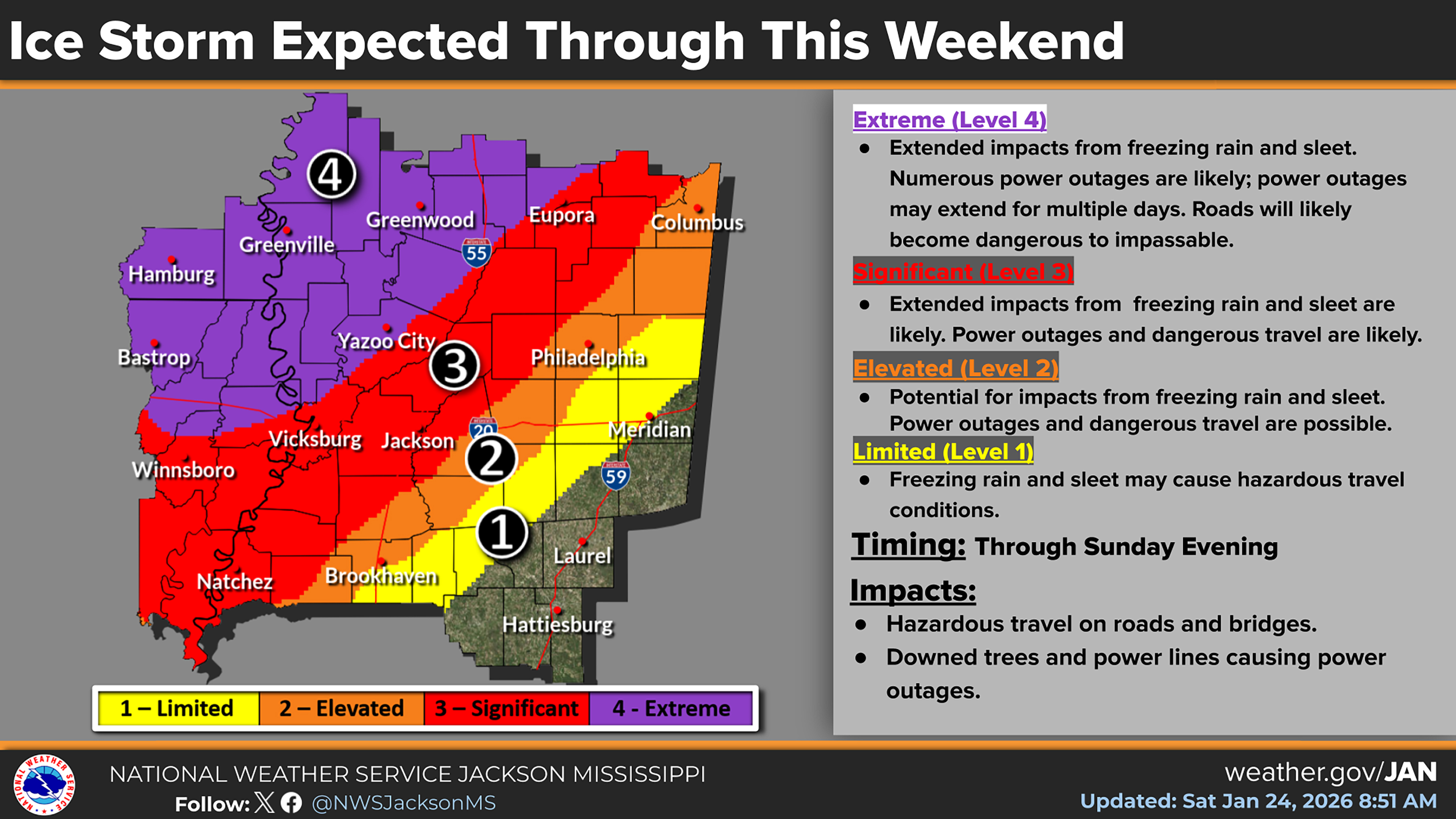
Grenada County remains at its highest winter weather alert level as a second, more dangerous wave of Winter Storm Fern moves into the area, prompting officials to warn residents to stay off the roads and prepare for possible extended power outages.
“We are in the most serious category,” Grenada Emergency Management Director Chris Whitehurst said Saturday afternoon. “People need to treat this like the life-threatening event it can be if the weather continues to deteriorate as predicted and they get out on these roads.”
At least two motor vehicle accidents have already been reported on Interstate 55 between the 206 and 211 mile markers by Grenada Emergency Operations Center dispatchers as a result of slick, icy roads, further underscoring the dangerous conditions. State transportation officials have reported ice on roads, bridges and overpasses in Grenada County and much of north Mississippi due to Winter Storm Fern, and have urged drivers to stay home unless travel is absolutely necessary. Whitehurst echoed that advice, asking residents to avoid driving during the height of the storm so emergency crews and utility workers can respond more quickly if trees and power lines come down.
 Numerous pieces of equipment and supplies - including mobile housing, food services and bathroom facilities - are currently mobilized at Camp McCain in anticipation of Winter Storm Fern's impact. | Photo by Adam Prestridge © 2026 Emmerich Newspapers, Inc.
Whitehurst said the county remains at Level 4 – Extreme, the National Weather Service’s (NWS) highest cold and winter weather alert level, as the second wave of the storm begins. He said conditions are expected to deteriorate tonight, Saturday, Jan. 24, and into Sunday, with additional ice accumulation between a ¼ inch and as much as 1 inch possible through midday Sunday.
Whitehurst added that the level of icing could quickly make travel hazardous to impassable and lead to downed trees and power lines as ice builds on limbs and utility infrastructure. He continued by stating that the county will stay under a Winter Storm Warning through 6 p.m. Sunday as Winter Storm Fern continues to impact the region.
Forecast guidance shared with local officials by the NWS just after 1 p.m. today, continues to show a 70 to 100 percent chance of at least ¼ inch of additional ice, a 40 to 80 percent chance of ½ inch and a 20 to 40 percent chance of reaching 1 inch of new accumulation. Whitehurst said those totals do not include existing ice, meaning overall glaze on trees, power lines and elevated surfaces could be substantial by Sunday. He also noted that wind gusts of 20 to 25 mph are expected between 4 a.m. and 10 a.m. Sunday, a period when trees and lines already weighted by ice will be especially vulnerable to falling.
“If we start getting that kind of wind on top of icing, we should expect trees and power lines to come down with possible long-duration outages,” Whitehurst said.
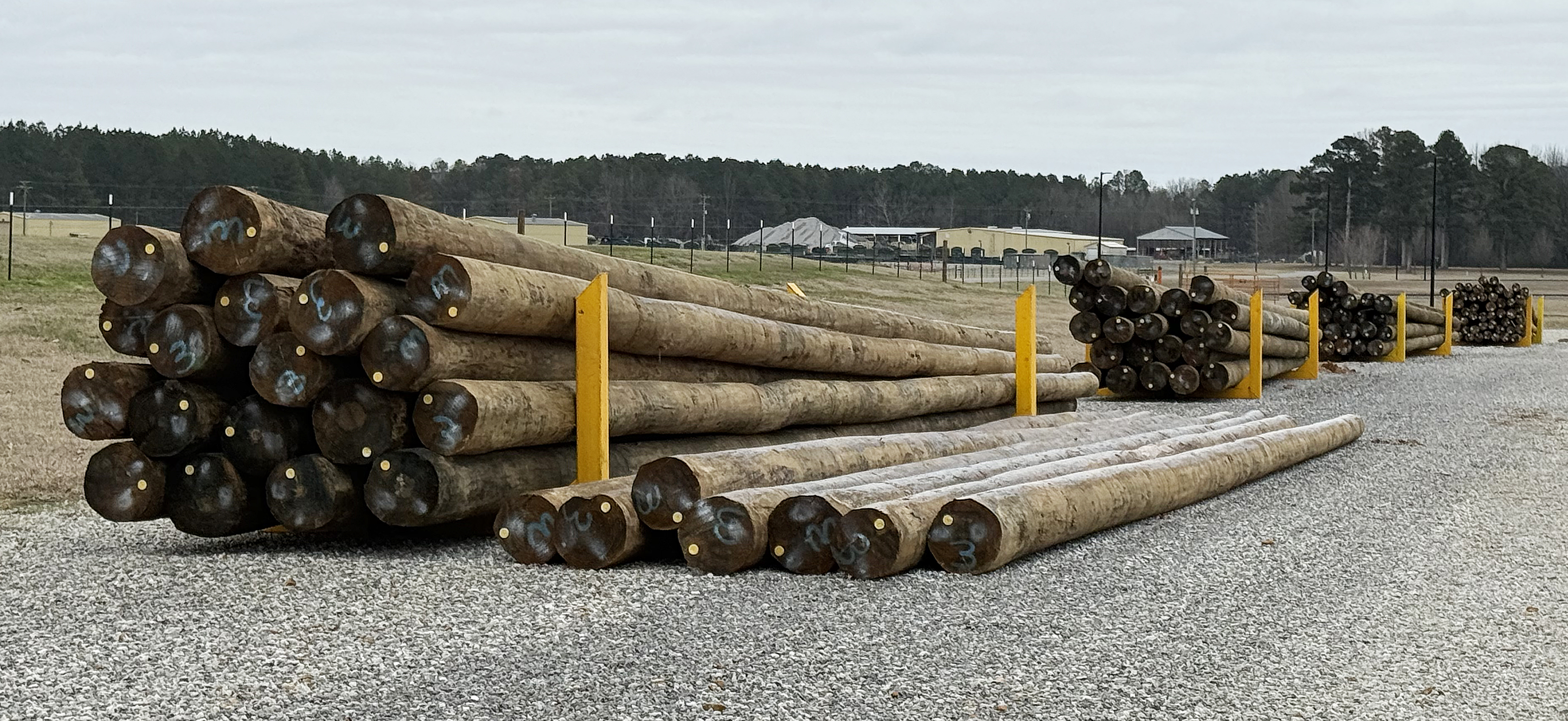 Dozens of utility poles are pictured Saturday morning stored at Camp McCain for use during Winter Storm Fern cleanup efforts. | Photo by Adam Prestridge © 2026 Emmerich Newspapers, Inc.
Along with ice, Whitehurst said a Level 4 cold warning is in effect through Monday, with wind chills expected to drop below 0 at times. Overnight lows are forecast to fall below 10 degrees, while Sunday and Monday high temperatures are not expected to climb above freezing, limiting any melt and allowing ice to persist on roads and other surfaces. He said the prolonged cold will add to the danger for anyone who loses power or becomes stranded, urging residents to have warm clothing, blankets and a safe heat source on standby. He also encouraged neighbors to check on elderly residents, those with medical needs and people who may not have adequate heat.
Officials also urge families to charge phones and other electronic devices, gather flashlights and batteries, and prepare for the possibility of being without electricity for an extended period if major damage occurs to the power grid. They encouraged residents to monitor local media, weather radios and official emergency management channels for updates as conditions change.
The Star will continue to post weather updates and alerts as new information is made available.